After two and a half years here I've finally made it up to the Demilitarized Zone, north of Seoul. Because there's without doubt a thousand other accounts already floating around online about the layout of the tour, I'll suffice to give a fairly brief account here.
We started at the USO in Seoul (USO, as explained by one of my American traveling companions, being the organization for morale boosting/recreational activities for the U.S. military). There we boarded a bus and met our Korean-American tour guide, Brandon. Brandon gave us the basic rundown on the DMZ during the hour long ride towards it.
Because our tour, unlike many of them, was going to include the JSA (Joint Security Area/Panmunjom), the dress code was fairly strict. Even though it was hot there was to be no shoulders shown or shorts higher than the knees, though pants were preferred.
We entered the DMZ and the bus wove between a series of strategically placed barriers of either side of the road, presumably designed to cause traffic to go slow and be rolled back into place if need be. When we reached the entrance to the JSA, Brandon announced that a U.S. soldier would take over for that portion of the tour and that we should do everything he said. The man who came to tell us to board a different bus for the ride into the JSA, bringing our cameras but absolutely no bags, had a firearm holstered at his side, reflective sunglasses, and a demeanor that suggested immediate reprimanding should we mess up. That's when this tour got real.
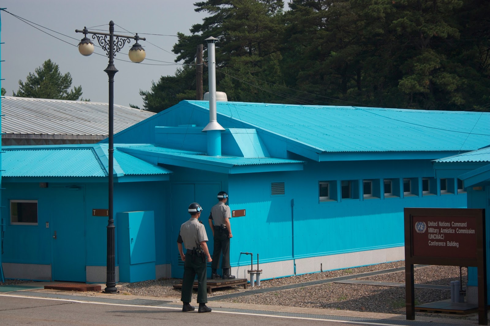
 After being given an opportunity to snap some pictures and take the sight in, we were led into the blue building on the left, which is the conference room where meetings take place between North and South. This room straddles both the North and South Korean side of the exact demarcation line, so by standing on the far side of the room we were actually in North Korea. There were two South Korean soldiers in here (again, "for our protection"), frozen in the first stance of Taekwondo. It was explained to us we could take pictures with them, but to stay an arm's length from them at all times "unless you want to find out what the second stance looks like." We had no reason not to believe him. These soldiers have been trained to serve at the raw focal point of the world's most heavily militarized border.
 After we left the conference building we boarded the bus again and went down the road, stopping at another point where we could disembark and look at a North Korean "propaganda" village in the near distance. Thanks to a zoom lens that my friend Sean and I were sharing, we were able to get some shots that, if you look very closely below, feature North Korean farmers working in the fields in front of the village. There's a massive flag pole supporting a giant flag that takes some crazy number like thirty men to hoist. Originally South Korea built a 98.4 meter flag pole flying the South Korean flag nearby, to which the North Koreans responded by building an even LARGER flag pole, which at that time was the tallest in the world and which is the one still there now. If there's ever been a clearer symbol of national dick waving in a war environment, I really don't know what it is.
We continued on down to the "Bridge of No Return," which you can see below, marked by four blue posts. Here POWs were lined up after the war, at which time they could choose to walk off the bridge into the North or South. Once they made their choice they could never go back, hence the name.
Before long we'd looped around a left the JSA, back in the regular DMZ area. We met our guide Brandon again and proceeded down the road to one of the old uncovered North Korean infiltration tunnels. Basically this was one of the secret tunnels North Korea was digging into South Korean land, through which thousands of soldiers would be able to move through within an hour. South Korea found the tunnel and blocked it off, but we could still go down into it (thankfully with hard hats, because anyone over about five and half feet had to crouch to avoid smashing their heads). At the time it was discovered, the North Koreans fervently claimed it was a coal mining tunnel, and retreating soldiers painted (yes, painted) a black strip along the wall to give the impression of a vein of coal. You'll never believe this, but no one bought the story.
The last stop on the tour was Dorasan station, now out of use. This station was where South Korean workers would board the train each day for the Kaesong Industrial complex, which North Korea shut down earlier this year in their latest game of raising the stakes, putting many South Korean workers out a job. We were able to walk about in the station and go out to the empty tracks. How many train stations can you see with Pyeongyang on the destination signs?
That was pretty much the end of the tour. I should mention that I didn't get to see the fanged deer that live in the DMZ (look it up, I'm not joking), nor did I catch a glimpse of a Korean tiger or leopard which are believed to still exist in extremely small numbers there. The DMZ is something of an involuntary nature reserve, due to it being fenced in on both sides, with very little human activity within, ever since the end of the Korean war. There was, however, a much larger number of white cranes in the fields we saw than I'm used to.
So if I never make it on a trip to the heart of North Korea (ideally the whole regime would just hurry up and crumble before I get a chance anyway), this was the closest I'll ever be. With that, it occurs to me that this was nowhere as "brief" an account as I claimed it to be at the beginning. Hooked you in, though, didn't I?
So if I never make it on a trip to the heart of North Korea (ideally the whole regime would just hurry up and crumble before I get a chance anyway), this was the closest I'll ever be. With that, it occurs to me that this was nowhere as "brief" an account as I claimed it to be at the beginning. Hooked you in, though, didn't I?
 |
| A North Korean soldier stares back from his side of the line. |

 |
| The so-called "propaganda" village. |
 |
| The soldiers were present with us at all times. |
 |
| The propaganda village. The soldiers told us that the lights come on in the buildings at night, though they glow brightest at the bottom floor of each building and dimmer on each successive one up, indicating that they're lit from the bottom and mostly hollow inside. |
 |
| What was at one time the world's tallest flag pole, flying the North Korean flag, towers over the propaganda village. If you look closely you can see North Korean farmers at the bottom of the picture, just above the tree line. |
 |
| Distant shot of The Bridge of No Return. |
 |
| Bridge of No Return |


 |
| Dorasan Station |
 |
| Probably the only place you're going to see a sign like this. |
No comments:
Post a Comment